Bangladesh: Land, People and History · Chapter 1 of 16
The Land and People of Bangladesh: Delta, Population and the Bengali Language
Bangladesh's sixth census, taken in June 2022, counted 165,158,616 people, and after a post-enumeration check the government adopted 169,828,911 as the official population.1 According to Banglapedia, about 98 per cent of them are Bengalis and 99.5 per cent speak Bangla, the state language; the other 2 per cent are ethnic minority peoples, of whom the census lists 50 communities, and non-Bengali Muslims.2 They live on about 147,570 square kilometres, most of it the combined delta of the Ganges, Brahmaputra and Meghna, one of the largest deltas in the world.3
- 169,828,911
- Official population, census 2022, after the post-enumeration check4
- 147,570 km²
- Area given by Banglapedia and, since 2018, by the World Bank5
- 98%
- Share of the population that is Bengali, according to Banglapedia6
- 91.08%
- Muslim share of the population, census 2022 national report7
- 50
- Ethnic communities listed separately in the 2022 census8
- 405 to 1,415
- Official counts of the country's rivers, 2011 to 20259
Sources: Banglapedia; World Bank; news reports of Bangladesh Bureau of Statistics releases; and the sources in the notes.10
What is the population of Bangladesh?
The official population of Bangladesh is 169,828,911, the adjusted total of the 2022 census; the World Bank's mid-year estimate for 2025 is 175,686,899.11
The count behind those numbers began on 15 June 2022. It was the country's sixth census and its first digital one: enumerators carried tablet computers and recorded each household's answers by computer-assisted personal interviewing.12 It was due to end on 21 June. In Sylhet, where floods had struck, it ran on until 28 June.13 Even counting the people had to wait for the water.
The preliminary result, published on 27 July 2022, was 165,158,616 people, not counting Bangladeshis living abroad.14 For the first time, women and girls outnumbered men and boys.15 The census also counted 12,629 people of the third gender (hijra).16
Then came the check. Between 10 and 16 October 2022 the Bangladesh Institute of Development Studies checked 39,003 households in 378 sample areas, and found a net coverage error of 2.75 per cent.17 The adjusted total, 169,828,911, adds 4,670,295 people to the enumerated count. It was published on 6 February 2023 and adopted as the official census figure on 9 April 2023.18 On that adjusted basis, 116,066,925 people (68.34 per cent) live in rural areas and 53,761,986 (31.66 per cent) in urban ones.19
Density depends on what you divide by. The preliminary census gave 1,119 people per square kilometre, up from 976 in 2011.20 Those figures match the enumerated counts divided by the total area of 147,570 km². The World Bank gives 1,301 per square kilometre for 2022, because it divides its own mid-year estimate by land area alone, 130,170 km², which leaves out rivers and other inland water.21 Both are right on their own terms. They should not be mixed.
Other figures from the census, as reported in the press, fill in the picture. Literacy among people aged seven and over rose from 51.77 per cent in 2011 to 74.66 per cent.22 There were about 41.0 million households, against 32.1 million in 2011.23 The census counted 1.736 million people living in slums, the first such count, and a floating population of 22,185.24 The annual growth rate between 2011 and 2022 was 1.22 per cent in the preliminary report and 1.12 per cent in the national report.25
One number shows how hard a mobile nation is to count. The national report recorded about 5.053 million Bangladeshi citizens living abroad, while the Bureau of Manpower, Employment and Training has recorded more than 14.9 million people as having gone abroad since 1976.26 The two figures measure different things, but the gap is wide.
| Division | Population | Share of total |
|---|---|---|
| Dhaka | 45,643,915 | 26.88% |
| Chattogram | 34,178,581 | 20.13% |
| Rajshahi | 20,794,023 | 12.24% |
| Rangpur | 18,020,073 | 10.61% |
| Khulna | 17,813,957 | 10.49% |
| Mymensingh | 12,637,524 | 7.44% |
| Sylhet | 11,415,021 | 6.72% |
| Barishal | 9,325,818 | 5.49% |
| Bangladesh | 169,828,911 |
Source: Bangladesh Bureau of Statistics, as reported by BSS in The Business Standard, 9 April 2023.27 As printed, the eight division figures add up to 169,828,912, one more than the national total; both are given here as the source prints them. Figures for each of the 64 districts are in the chapter on districts.
This chapter makes one argument, and it starts here. Almost every basic fact about Bangladesh comes with a second figure attached: two population totals, several areas, two densities, half a dozen counts of the rivers, several heights for the highest hills. In the interpretation offered here, which the evidence supports but no single source states, that is not mainly a failure of record-keeping. It is what measuring a living delta looks like, where rivers still build and remove land and a large, mobile population is hard to pin down. What has held steady through all of it is the language that gives the majority its name.
Who are the Bengali people?
The Bengalis, or Bangalees, are the majority people of Bangladesh, about 98 per cent of its population according to Banglapedia, and the clearest thing they share is a language, Bangla (বাংলা).28 Banglapedia's country entry says 99.5 per cent of people speak it.29 The other 2 per cent are the ethnic minority peoples described below and non-Bengali Muslims.30
The constitution writes this identity into law. As published on the government's legal database in November 2026, Article 6(2) reads: "The people of Bangladesh shall be known as Bangalees as a nation and the citizens of Bangladesh shall be known as Bangladeshies."31 Article 3 states: "The state language of the Republic is Bangla".32 Until 1988 the article said "Bengali"; the Constitution (Eighth Amendment) Act of that year replaced it with "Bangla".33 The constitution thus gives the nation one name, Bangalees, and the citizens another, Bangladeshies. Why language came to carry so much political weight is the subject of the chapter on East Pakistan.
Where did the Bangla language come from?
Bangla is an Indo-Aryan language of the Indo-European family, and with Assamese it is the easternmost of the group.34 It emerged by about 900 to 1000 CE through two stages of Magadhi Prakrit, known as Magadhi apabhramsha and abahattha, at about the same time as Oriya and Assamese.35 Scholars divide its history into Old Bangla (900 or 1000 to 1350), Middle Bangla (1350 to 1800) and Modern Bangla (from 1800).36 The foundational study of that history is Suniti Kumar Chatterji's The Origin and Development of the Bengali Language (1926).37
Chatterji grouped the dialects of Bangla into four, called Radh, Banga, Kamrupa and Varendra; Sukumar Sen, in 1939, made it five by adding Jharkhandi.38 The Radhi dialect is the basis of standard colloquial Bangla.39
Bangla prose has a surprising birthplace: the Bengali department of Fort William College in Calcutta, opened in 1801, where it was developed under the missionary William Carey.40 Newspapers came late to the everyday form of the language: many adopted the colloquial (chalita) form from March 1965; Ittefaq switched only in 2001.41 The language also carries its history in its vocabulary: over 2,000 Arabic and Persian words remain in use.42
The Charyapada, the oldest Bangla poems
The earliest surviving poems in Bangla were found not in Bengal but in Nepal. In 1907 the Sanskrit scholar Haraprasad Shastri found a palm-leaf manuscript in the royal library of Nepal, and the Bangiya Sahitya Parishad published it in 1916 under the title Hajar Bachharer Purana Bangala Bhasay Bauddhagan O Doha.43 The manuscript holds 47 verses by 23 poets.44 They are usually dated to the ninth to eleventh centuries, though the philologist Muhammad Shahidullah placed them in the seventh and eighth.45 They were songs, not just poems: each verse names the raga and tala to which it was sung.46 The Charyapada's place in the longer history of Bengali literature is followed in the chapter on culture.

The Bangla script
The Bangla script descends from the northern Brahmi script.48 The Mahasthan Brahmi inscription, discussed in the chapter on ancient Bengal, is regarded as the oldest written object found in Bengal.49 "Proto-Bangla" letters appear in copper plates of the second half of the ninth century and of the tenth, and the script took its Bangla form in the eleventh and twelfth centuries.50 The Sundarban copper plate of Dommonpala, dated 1196 CE, is mainly in complete Bangla letters, and a Pancaraksa manuscript of about 1289 CE, now in Cambridge University Library, is written entirely in Bangla script.51
Counting the people, 1872 to 2022
The territory that is now Bangladesh has been counted since 1872, but its population series has to be stitched together from the censuses of three states, British India, Pakistan and Bangladesh, and not all of them can be trusted equally.52 The first census in Bengal was taken under British rule in 1872.53 Banglapedia regards the censuses of 1901, 1911 and 1921 as fairly reliable, says those of 1931 and 1941 lost credibility because of communal over-reporting, and calls the 1961 census "the most reliable count undertaken since 1901".54
Before 1872 there are only estimates. Banglapedia gives about 14.5 million people in the area in 1801 and 20.3 million in 1851.55 The 1951 census of Pakistan later recalculated the colonial counts to the new boundaries of East Bengal, which is how the series below was built.56 The influenza epidemic of 1918 alone caused 400,000 deaths, according to Banglapedia.57
| Year | Population | Basis |
|---|---|---|
| 1801 | 14.5 million | Historical estimate (Banglapedia) |
| 1851 | 20.3 million | Historical estimate (Banglapedia) |
| 1901 | 28,927,786 | Census, recalculated to 1951 boundaries |
| 1911 | 31,555,056 | Census, recalculated to 1951 boundaries |
| 1921 | 33,254,096 | Census, recalculated to 1951 boundaries |
| 1931 | 35,604,170 | Census, recalculated to 1951 boundaries |
| 1941 | 41,997,297 | Census, recalculated; thought to be over-enumerated |
Source: Banglapedia, "Population"; Census of Pakistan, 1951, vol. 3, Statement 3.3.58
The 1941 figure was soon doubted. The 1951 report itself says the 1941 count for the province "may have been caused by over-enumeration".59 The first census of East Bengal under Pakistan was taken from 9 to 28 February 1951 and enumerated 42,062,610 people.60 Ten years later the 1961 report restated that figure as 41,932,329, leaving out non-Pakistanis.61 So even the starting point of the modern series has two official values, and a third, 44.2 million, if Banglapedia's adjusted back-estimate is used.62
The 1961 census, taken from 12 to 31 January, counted 50,840,235 people in East Pakistan excluding non-Pakistanis: 26,348,843 men and boys (51.8 per cent) and 24,491,392 women and girls (48.2 per cent).63 Including 13,486 non-Pakistanis, the total was 50,853,721.64 On the 1961 report's own basis East Pakistan had grown by 21.2 per cent in ten years.65 Karol Krotki, research adviser at the Institute of Development Economics, noted at the time that the reported growth for Pakistan as a whole, 23.7 per cent (nearly 2.2 per cent a year), was only as accurate as the relative completeness of the two counts.66
Bangladesh's first census after independence, due in 1971, was held in 1974.67 Later censuses followed in 1981, in March 1991, in January 2001, in March 2011 and in June 2022.68 Each of them has an adjusted figure, corrected upwards for people the enumerators missed.69 The table and chart below set the enumerated and adjusted figures side by side. The enumerated total for 2011 and both figures for 2022 are as reported in the press from Bangladesh Bureau of Statistics releases, because the bureau's own reports could not be opened for this chapter.
| Census | Count dates | Enumerated | Adjusted or revised |
|---|---|---|---|
| 1951 | 9 to 28 February 1951 | 42,062,610 | 41,932,329 (1961 report, excluding non-Pakistanis); 44.2 million (BBS back-estimate) |
| 1961 | 12 to 31 January 1961 | 50,840,235 (excluding non-Pakistanis) | 55.2 million (BBS back-estimate) |
| 1974 | 1974 | 71,479,071 | 76.4 million |
| 1981 | 1981 | 87,119,965 | 89.9 million |
| 1991 | 12 to 15 March 1991 | 106,314,992 | 111.5 million |
| 2001 | 23 to 27 January 2001 | 124,355,263 | 130.5 million |
| 2011 | 15 to 19 March 2011 | 144,043,697 (as reported) | 149.8 million |
| 2022 | 15 to 28 June 2022 | 165,158,616 (as reported) | 169,828,911 (post-enumeration check, as reported) |
Source: Census of Pakistan 1951 and 1961; Banglapedia, "Population" and "Census"; Prothom Alo, 27 July 2022; Bangladesh Post, 27 July 2022; bdnews24.com, 6 February 2023; BSS, 9 April 2023.70
Show the numbers
| Year | Enumerated | Adjusted |
|---|---|---|
| 1951 | 42.06 | 44.2 |
| 1961 | 50.84 | 55.2 |
| 1974 | 71.48 | 76.4 |
| 1981 | 87.12 | 89.9 |
| 1991 | 106.31 | 111.5 |
| 2001 | 124.36 | 130.5 |
| 2011 | 144.04 | 149.8 |
| 2022 | 165.16 | 169.83 |
Source: As in the table above. The adjusted figures for 1951 and 1961 are back-estimates by the Bangladesh Bureau of Statistics, not census counts; the 2011 enumerated total and the 2022 figures are as reported in the press.71 Download CSV
Even the growth rates disagree. For 2001 to 2011, published figures include 1.37, 1.46, 1.566 and 1.86 per cent a year, two of them in the same newspaper article.72 The balance between the sexes has shifted too: the sex ratio was 104.5 men to every 100 women in 1901, 109.7 in 1951 and 100.3 in 2011, before women became the majority in 2022.73
Religion in Bangladesh
About nine in ten people in Bangladesh are Muslim: the national report of the 2022 census gives 91.08 per cent Muslim, 7.96 per cent Hindu, 0.61 per cent Buddhist, 0.30 per cent Christian and 0.06 per cent followers of other religions.74 The preliminary report of July 2022 had given slightly different shares, shown in the table below.75
In numbers, the national report counted more than 15 crore (150 million) Muslims, up from 13 crore; 1.31 crore (13.1 million) Hindus, up from 1.23 crore; 10.2 lakh (1.02 million) Buddhists, up from 8.9 lakh; 4.89 lakh (489,000) Christians, up from 4.48 lakh; and 1.1 lakh (110,000) people of other religions, down from 2.2 lakh.76 On the adjusted total, the Bureau's figure for Muslims is 154,542,078.77
| Census | Muslim | Hindu | Buddhist | Christian | Other |
|---|---|---|---|---|---|
| 2011 | 90.39 | 8.54 | 0.62 | 0.31 | 0.14 |
| 2022, preliminary report | 91.04 | 7.95 | 0.61 | 0.30 | 0.12 |
| 2022, national report | 91.08 | 7.96 | 0.61 | 0.30 | 0.06 |
Source: Bangladesh Bureau of Statistics, as reported in The Business Standard, 27 July 2022, and The Daily Star, 28 November 2023.78
The Hindu share varies by region. In 2022 it was highest in Sylhet Division, at 13.5 per cent, and lowest in Mymensingh, at 3.92 per cent; in Khulna it fell from 12.85 per cent in 2011 to 11.52 per cent.79 Reports of the Bureau's figures give two reasons for the long fall in the Hindu share: people moving out of the country, and lower fertility.80
That fall is old. In 1901 about two-thirds of the people of the territory were Muslim and a third Hindu.81 The sharpest change came with Partition. The 1951 census found 76.85 per cent Muslims, 22.04 per cent Hindus (a figure that includes the scheduled castes) and 1.11 per cent others in East Bengal.82 Its report described a rise from just over 70 per cent Muslim in 1931 to nearly 77 per cent, and put it down to "the large influx of Muslims and a considerable exodus of Hindus" after 1947.83 Banglapedia's series, used in the chart below, gives a slightly lower 69.5 per cent for 1931.84
Show the numbers
| Year | Muslim | Hindu |
|---|---|---|
| 1901 | 66.1 | 33 |
| 1911 | 67.2 | 31.5 |
| 1921 | 68.1 | 30.6 |
| 1931 | 69.5 | 29.4 |
| 1941 | 70.3 | 28 |
| 1951 | 76.85 | 22.04 |
| 1961 | 80.4 | 18.5 |
| 1974 | 85.4 | 13.5 |
| 1981 | 86.7 | 12.1 |
| 1991 | 88.3 | 10.5 |
| 2001 | 89.7 | 9.2 |
| 2011 | 90.39 | 8.54 |
| 2022 | 91.08 | 7.96 |
Source: Banglapedia, "Population", Table 3 (1901 to 1941 and 1961 to 2001); Census of Pakistan 1951, Statement 3.4 (1951; the Hindu figure includes scheduled castes); The Daily Star, 28 November 2023 (2011 and the 2022 national report). Banglapedia's "Census" entry gives 87 per cent Muslim for 1991, against 88.3 per cent in its "Population" entry.85
The constitution names a state religion and promises equality in the same sentence. Article 2A, as substituted in 2011 and as published on the government's legal database in November 2026, reads: "The state religion of the Republic is Islam, but the State shall ensure equal status and equal right in the practice of the Hindu, Buddhist, Christian and other religions."86
Why did Islam take such deep root in eastern Bengal? The historian Richard Eaton's answer ties religion to the land itself. He argues that Islam spread there mainly through the expansion of farming into the active delta as the rivers shifted east, not through forced conversion.87 It is an interpretation, not a settled fact, but it fits this chapter's theme: in Bengal, where the water went, people followed. The medieval background is told in the chapter on the Bengal Sultanate.
The other peoples of Bangladesh
The 2022 census counted 1,650,159 people belonging to 50 ethnic communities, against 1,586,141 in 2011, when they made up 1.10 per cent of the population.88 Community leaders, including the Bangladesh Adivasi Forum, say the true number is no fewer than 3 million.89 Even the name is disputed: the census speaks of "ethnic communities", the constitution of "tribes, minor races, ethnic sects and communities", and a Santal leader quoted in The Daily Star complained that the government "changed the name from Adivasi to small ethnic communities".90 This chapter uses the census's term without taking a side.
Four communities make up most of the count. The Chakma, with 483,299 people, are 29.29 per cent of the ethnic population, followed by the Marma (224,261; 13.59 per cent), the Tripura (156,578; 9.49 per cent) and the Santal (129,049; 7.82 per cent), according to census figures a minister gave in parliament in June 2026, as reported by UNB.91 The Garo (Mandi) numbered 76,846.92 Most people of the ethnic communities live in Chattogram Division, 990,860 in all, including 372,864 in Rangamati, 349,378 in Khagrachhari and 197,975 in Bandarban.93
| Community | 1991 census | 2022 census |
|---|---|---|
| Chakma | 252,258 | 483,299 |
| Marma | 157,301 | 224,261 |
| Tripura | 79,772 | 156,578 |
| Santal | 202,162 | 129,049 |
| Garo (Mandi) | 64,280 | 76,846 |
| All ethnic communities | 1,205,978 | 1,650,159 |
Source: Banglapedia, "Population" (1991); UNB, 25 June 2026, and The Daily Star, 9 August 2022 (2022). The 2022 census listed 50 communities; counts for the other 45, and so the Garo's rank, were not found in the sources for this chapter.94
The Chittagong Hill Tracts, home of the largest communities, cover about 13,184 square kilometres, about a tenth of the country.100 The British annexed them in 1860, and the Chittagong Hill Tracts Regulation of 1900 set up a system of chiefs and headmen.101 On 2 December 1997 the government signed a peace accord with the Parbatya Chattagram Jana Samhati Samiti, ending about two decades of armed insurgency.102
The Chakma are the largest single group: over 90 per cent of them live in Rangamati and Khagrachhari, and about 100,000 more live in India.103 Their presence is old. On the earliest surviving map of Bengal, drawn by the Portuguese mapmaker Lavanha in about 1550, a Chakma settlement is marked on the Karnafuli River.104 The Marma live in Rangamati, Bandarban and Khagrachhari, with some in Cox's Bazar and Patuakhali, and write their language in Burmese characters.105
Outside the hills, the Santal live mainly in Rajshahi Division. Banglapedia says censuses after 1947 did not count them separately, though the 1991 census recorded over 200,000.106 Garo society is matrilineal: children take their mother's clan name, and property passes to a chosen daughter, the nakna, usually the youngest. The five main Garo clans are the Sangma, Marak, Momin, Shira and Areng.107
The constitution, since an amendment of 2011, includes Article 23A. As published on the government's legal database in November 2026, it reads: "The State shall take steps to protect and develop the unique local culture and tradition of the tribes, minor races, ethnic sects and communities."108
Bangladesh is also home to people who are not its citizens. According to UNHCR, Bangladesh hosts close to one million Rohingya refugees from Myanmar, in 33 camps in Cox's Bazar District.109
The delta, the chars and the Sundarbans
Most of Bangladesh is land the rivers have built: the country is composed mainly of the combined delta of the Ganges, Brahmaputra and Meghna, and Quaternary sediments laid down by those rivers cover about three-quarters of it.110 The land falls into three physical units: the Tertiary hills, the Pleistocene uplands of the Madhupur and Barind tracts, and the Recent plains.111
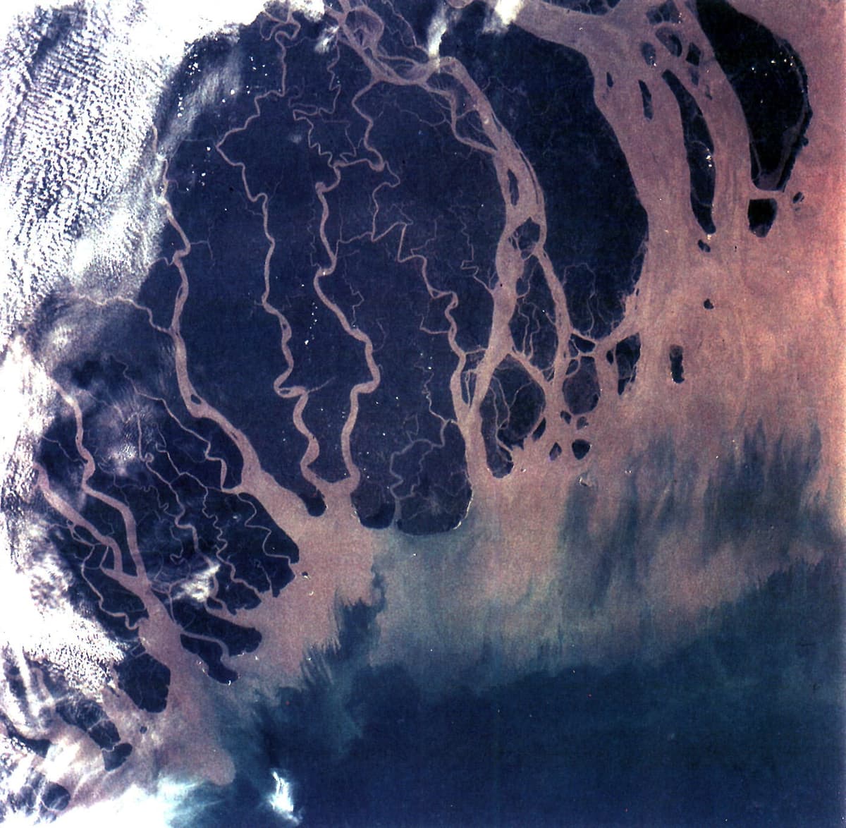
The delta is old and young at once. Its development began some 125 million years ago, after the break-up of Gondwanaland, and it continues today.113 Delta-building by the rivers formed some 60 per cent of the Bangladesh coastline.114 Banglapedia divides it into a western, inactive delta of about 31,500 square kilometres in Bangladesh and an eastern, active delta of about 15,000.115 In Khulna, Barisal, southern Faridpur and eastern Noakhali the delta's average elevation is less than 2 metres.116
The rivers that make land also take it away, and the word for what they leave is char: land accreted in a river course or estuary.117 Island chars are surrounded by water all year; attached chars are joined to the mainland when the river runs at normal levels.118 A dry-season Landsat image of 1992 showed 56 large island chars, each longer than 3.5 km, and 226 small ones in the Jamuna alone.119 The same rivers wear away their banks: about 729,000 people were displaced by riverbank erosion in Bangladesh between 1981 and 1993.120
The Sundarbans
Part of the delta's coast is covered by the Sundarbans, which UNESCO calls the largest contiguous mangrove forest in the world and the only mangrove habitat of the tiger, Panthera tigris tigris.121 The whole forest covers about 10,000 square kilometres, 60 per cent of it in Bangladesh.122 UNESCO inscribed the Bangladesh Sundarbans on the World Heritage List in 1997, under criteria (ix) and (x), with a property area of 139,500 hectares; India's part had been inscribed in 1987.123
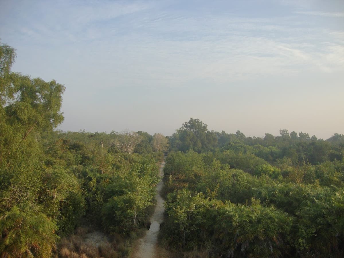
How many tigers live there depends on which source you read. UNESCO's description still quotes older estimates of 400 to 450.124 Camera-trap surveys give far lower numbers. The latest government survey, run from January 2023 to March 2024 with 1,210 cameras in 605 grids, counted 125 tigers in the Bangladesh Sundarbans, against 114 in 2018 and 106 in 2015.125
| Survey | Tigers | Tigers per 100 km² |
|---|---|---|
| 2015 | 106 | 2.17 |
| 2018 | 114 | 2.55 |
| 2023 to 2024 | 125 | 2.64 |
Source: The Financial Express, 9 October 2024.126
The rivers of Bangladesh
Bangladesh's rivers belong to four great systems: the Brahmaputra-Jamuna, the Ganges-Padma, the Surma-Meghna and the rivers of the Chittagong region.127 Banglapedia counts about 700 rivers including tributaries, with a total length of about 24,140 km.128
The Ganges rises as the Bhagirathi at Gaumukh, on the Gangotri glacier.129 Its total length is about 2,600 km in one Banglapedia entry and 2,510 km in another.130 Inside Bangladesh it runs about 258 km from the western border to Goalandaghat, about 72 km west of Dhaka, where it meets the Jamuna.131 Its highest recorded flow was 76,000 cubic metres a second in 1981; the average is about 11,500.132 Below Goalandaghat the combined river is called the Padma, which runs about 120 km to Chandpur, where it joins the Meghna, and is 4 to 8 km wide.133
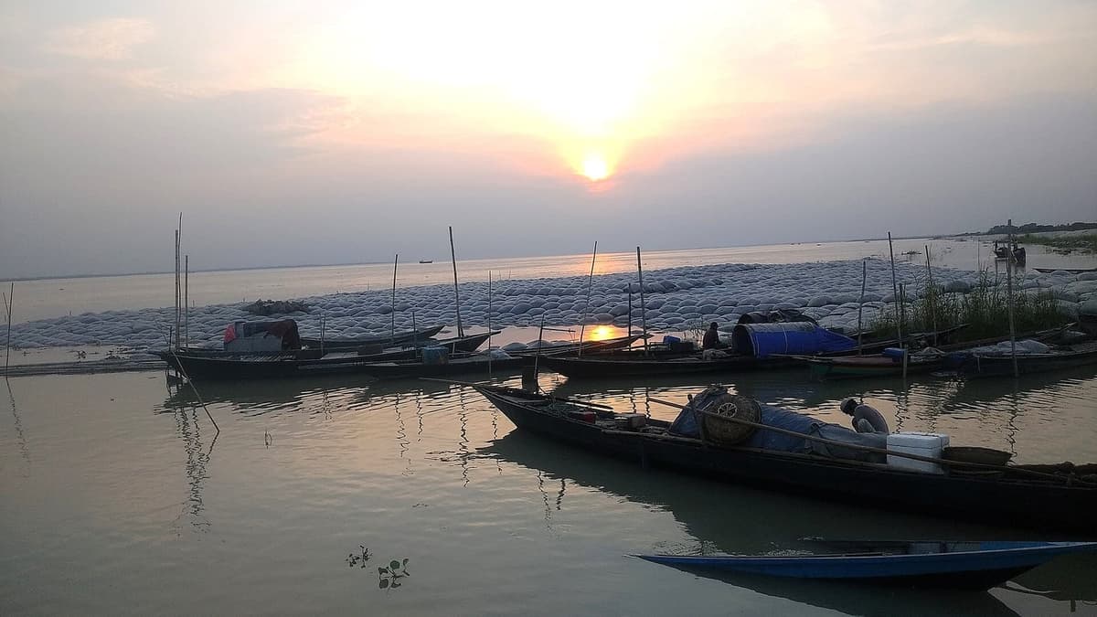
The Brahmaputra has the more restless history. The Tsangpo-Brahmaputra-Jamuna is about 2,700 km long to its meeting with the Ganges, or about 2,850 km if the Padma and Meghna are counted to the sea.135 Its catchment covers about 583,000 square kilometres: 293,000 in Tibet, 241,000 in India and only 47,000 in Bangladesh.136 Inside Bangladesh the Brahmaputra-Jamuna runs 276 km, of which the Jamuna is 205 km (207 in another Banglapedia table) and the Brahmaputra, down to where the Old Brahmaputra branches off, 69 km.137 Its highest recorded flood discharge was 98,600 cubic metres a second, in August 1988.138
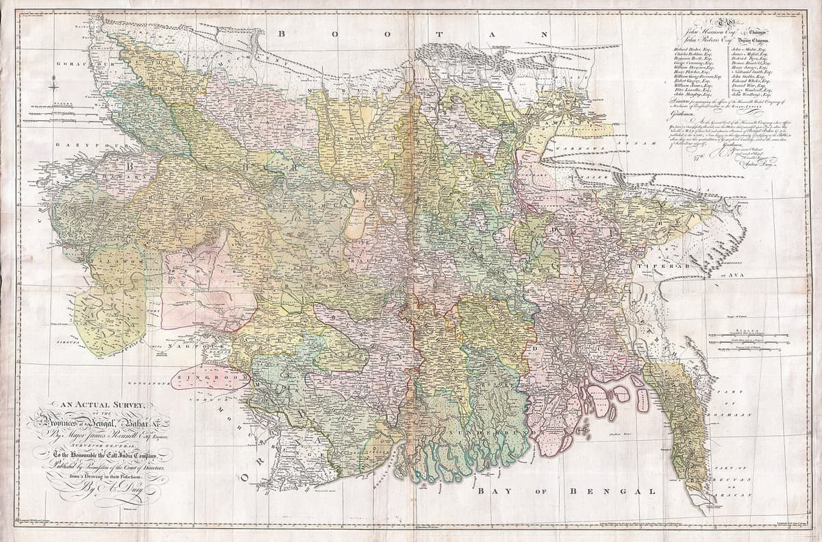
After an earthquake and catastrophic flood in 1782 to 1787, the Brahmaputra moved to its present course, the Jamuna; one Banglapedia entry dates the switch to 1787.139 Its older, eastern course is shown in the atlas of James Rennell, who became Surveyor General of Bengal in 1767.140 The date of that atlas is not settled in the sources: Banglapedia's entry on Rennell dates his Bengal Atlas to 1779, while its Brahmaputra entry refers to "Rennell's atlas (1785)", perhaps a different edition.141 The colonial period in which Rennell worked is the subject of the chapter on colonial Bengal.
The third system, the Surma-Meghna, is the longest river system in the country, at about 670 km.143 The Barak-Meghna as a whole is 950 km long, of which 340 km lies in Bangladesh.144 Its last stretch, the Lower Meghna, runs about 160 km from south of Chandpur to the Tentulia; its estimated annual discharge is about 875 million acre-feet, and it carries about 1,500 million tons of sediment a year.145
Two long bridges now cross the largest rivers. The Bangabandhu Jamuna Multipurpose Bridge, 4.8 km long, opened to traffic on 23 June 1998; the Padma Bridge, 6.15 km long, opened on 25 June 2022.146
| River or reach | Length | Other figures |
|---|---|---|
| Ganges, total | about 2,600 | 2,510 (Banglapedia, "River") |
| Ganges in Bangladesh (border to Goalandaghat) | 258 | |
| Padma (Goalandaghat to Chandpur) | about 120 | 341 (National River Conservation Commission, 2023, for a longer reach) |
| Tsangpo-Brahmaputra-Jamuna, to the Ganges | about 2,700 | about 2,850 to the sea |
| Brahmaputra-Jamuna in Bangladesh | 276 | |
| Jamuna | 205 | 207 |
| Surma-Meghna | about 670 | 669 |
| Barak-Meghna, total and in Bangladesh | 950 and 340 | |
| Lower Meghna | about 160 | |
| Karatoya-Atrai-Gur-Gumani-Hurasagar | 597 | |
| Gorai-Madhumati-Baleshwar | 371 | |
| Matamuhuri | 287 | |
| Karnafuli | 180 | |
| Tista (in Bangladesh) | 115 | |
| Buriganga | 27 |
Source: Banglapedia entries "River", "Ganges-Padma River System", "Padma River", "Jamuna River", "Brahmaputra River", "Meghna River" and "Surma-Meghna River System"; The Financial Express, 25 September 2023.147
How many rivers does Bangladesh have?
There is no single answer: the official count has more than tripled in fourteen years. In 2011 the Bangladesh Water Development Board published a count of 405 rivers.148 In September 2020 the National River Conservation Commission put the number at over 770.149 It published a draft list of 907 on 10 August 2023, and presented 1,008 at a seminar on 24 September 2023.150 A draft government list of 1,294 was published on the Ministry of Water Resources website on 27 March 2025, and the joint list later issued by the Ministry of Water Resources, the Ministry of Shipping, the Water Development Board and the Commission gives 1,415.151
| Year | Count | Body |
|---|---|---|
| 2011 | 405 | Bangladesh Water Development Board |
| 2020 | over 770 | National River Conservation Commission (from field administrations) |
| August 2023 | 907 (draft) | National River Conservation Commission |
| September 2023 | 1,008 | National River Conservation Commission |
| March 2025 | 1,294 (draft) | Ministry of Water Resources |
| 2025 | 1,415 | Ministry of Water Resources, Ministry of Shipping, Water Development Board and River Conservation Commission |
Source: Prothom Alo, 28 September 2020 and 26 August 2023; The Financial Express, 25 September 2023; Bonik Barta, 31 March 2025; bdnews24.com, 6 October 2025.152
Outside the official lists the numbers spread further. A river expert quoted in 2020 gave 1,178, and experts quoted in 2025 say there are over 2,000.153 Professor Ainun Nishat disagreed with the Commission's method.154 Even the longest river changed: the Commission's seminar of September 2023 named the Padma, at 341 km, while its draft list a month earlier had named the Ichamati.155 The sources opened for this chapter do not set out the full method behind each list. What they show is that the answer depends on who is counting and on what counts as a river. Since 3 February 2019 the question has had legal weight: the High Court named the Commission the guardian of all rivers and described rivers as living entities.156
Monsoon, floods and cyclones
Bangladesh has a sub-tropical monsoon climate, and most of its rain falls in the monsoon months of June to October.157 The year has three seasons: cool and dry from November to February, hot from March to May, and the rainy monsoon from June to October.158 The summer monsoon arrives in late May or early June; the word itself comes from the Arabic mawsim, "season".159 Average maximum and minimum temperatures are about 29°C and 11°C in winter and 34°C and 21°C in summer.160
Monsoon rain makes up about 70 per cent of the year's rainfall in the east, 80 per cent in the south-west and over 85 per cent in the north-west; winter brings only 2 to 4 per cent.161 Annual rainfall ranges from 150 cm in the west-centre to more than 400 cm in the north-east and south-east, according to Banglapedia's climate entry; its country entry gives 1,194 to 3,454 mm.162
Floods are part of the year, and some years they are disasters. In severe floods more than 55 per cent of the country may be under water, and in 1998 over two-thirds of it was flooded.163 Banglapedia describes the floods of 1987, 1988 and 1998 as catastrophic.164
Cyclones come from the sea. The word "cyclone" itself was coined by Henry Piddington, a meteorologist in Calcutta, in The Sailor's Horn-book for the Law of Storms (1848).165 The cyclone of 12 and 13 November 1970 struck the coast of what was then East Pakistan with a storm surge of 6 to 10 metres and winds of about 222 km an hour.166 In 2017 the World Meteorological Organization's archive of weather and climate extremes named it the deadliest tropical cyclone on record, with an estimated 300,000 deaths; a WMO article of 2020 gives "an estimated 300,000 to 500,000 fatalities", and Banglapedia gives 0.5 million.167 Its political consequences belong to the chapter on East Pakistan.
The cyclone of 29 April 1991 had a maximum observed wind speed of 225 km an hour at Sandwip; Banglapedia's cyclone entry gives its death toll as both 140,000 and 150,000.168 Cyclone Sidr, in November 2007, killed about 3,000 people, and Cyclone Aila, in May 2009, about 150.169 Bimal Kanti Paul has explained Sidr's much lower toll, compared with 1970 and 1991, by warnings and cyclone shelters.170 The WMO also lists a tornado of 1989 at Manikganj, which killed an estimated 1,300 people, as the deadliest tornado on record.171
| Date | Cyclone | Deaths |
|---|---|---|
| 12 and 13 November 1970 | The 1970 (Bhola) cyclone | About 300,000 (WMO, 2017); 300,000 to 500,000 (WMO, 2020); 0.5 million (Banglapedia) |
| 29 April 1991 | The cyclone of 1991 | 140,000 or 150,000 (both in Banglapedia) |
| 15 to 17 November 2007 | Sidr | About 3,000 |
| 27 to 29 May 2009 | Aila | About 150 |
Source: UN News, 18 May 2017; World Meteorological Organization, 2020; Banglapedia, "Cyclone".172
How big is Bangladesh, and how high?
Bangladesh covers 147,570 square kilometres according to Banglapedia and, since 2018, the World Bank; but the World Bank's series, drawn from the FAO, gave 148,460 km² for every year from 1961 to 2013, and the country's land area, without its rivers and other inland water, is 130,170 km².173 Between those two periods the series gives 147,630 km² for 2014 to 2016 and 147,977 km² for 2017.174 The sources opened for this chapter do not explain the revision. For comparison, the 1961 census gave East Pakistan's area as 55,125 square miles.175
| Source | Area | Years |
|---|---|---|
| Banglapedia | 147,570 km² | current |
| World Bank and FAO, surface area | 148,460 km² | 1961 to 2013 |
| World Bank and FAO, surface area | 147,630 km² | 2014 to 2016 |
| World Bank and FAO, surface area | 147,977 km² | 2017 |
| World Bank and FAO, surface area | 147,570 km² | 2018 to 2024 |
| World Bank and FAO, land area only | 130,170 km² | 1961 to 2024 |
| Census of Pakistan, 1961 | 55,125 square miles | 1961 |
Source: Banglapedia, "Bangladesh"; World Bank, World Development Indicators, series AG.SRF.TOTL.K2 and AG.LND.TOTL.K2; Census of Pakistan 1961, Table 1.176
The country lies between 20°34′ and 26°38′ north and 88°01′ and 92°41′ east, and stretches about 440 km from east to west and 760 km from north-north-west to south-south-east.177 Its land border is about 4,246 km long, 93.9 per cent of it with India and about 6 per cent with Myanmar.178 West Bengal lies to the west; West Bengal, Assam and Meghalaya to the north; Assam, Tripura, Mizoram and Myanmar to the east; and the Bay of Bengal to the south.179 At sea, Bangladesh claims territorial waters of 12 nautical miles and an exclusive economic zone of 200 nautical miles from its baselines.180
The borders themselves were settled late, on land and at sea. A Land Boundary Agreement with India was signed on 16 May 1974, but the exchange of enclaves it provided for took effect only at midnight on 31 July 2015, after a protocol of 6 September 2011: 111 Indian enclaves in Bangladesh and 51 Bangladeshi enclaves in India, 162 in all, changed hands, and residents could move to the mainland of either country until 30 November 2015.181 At sea, the International Tribunal for the Law of the Sea ruled on the boundary with Myanmar on 14 March 2012, and in the arbitration with India the tribunal awarded Bangladesh 19,467 km² of a disputed area of 25,602 km², figures announced by the foreign minister on 8 July 2014.182
- 16 May 1974India and Bangladesh sign the Land Boundary Agreement.183
- 6 September 2011The protocol to the agreement is signed.184
- 14 March 2012The International Tribunal for the Law of the Sea rules on the maritime boundary with Myanmar.185
- 8 July 2014Bangladesh announces the award in its maritime arbitration with India: 19,467 km² of 25,602 km² in dispute.186
- 31 July 2015At midnight, 162 enclaves are exchanged between India and Bangladesh.187
- 30 November 2015Deadline for enclave residents to move to the mainland of either country.188
Inside those borders, Banglapedia's 2022 figures list 8 divisions, 64 districts, 495 upazilas, 4,578 unions, 12 city corporations and 331 municipalities.189 The chapter on districts gives the figures for each district.
What is the highest point in Bangladesh?
The highest point is disputed, and no single official height was found for this chapter. Banglapedia's physiography entry names Tajingdong, officially called "Bijoy", as the highest peak at 1,280 m, followed by Mowdok Mual (1,004 m), Rang Tlang (958 m), Mowdok Tlang (905 m) and Waibung (808 m).190 Its country entry places the 1,280 m maximum in the Saichal Range.191
That uncertainty about something as solid as a mountain is a fitting place to end. In a country where the area has been revised, the river count has more than tripled, the census is corrected after it is taken and even the highest hills have several heights each, the evidence suggests the numbers will keep moving, because the land and its people do. The rivers still build chars and take them away, and millions of Bangladeshis live abroad. What the census, the constitution and a thousand years of manuscripts agree on is the language: Bangla, the thread that runs from the Charyapada to the census enumerator's tablet.
Further reading
Six works make a good start. Willem van Schendel's A History of Bangladesh (2nd ed., 2020) is the standard one-volume history, and it opens with the land, the rivers and the delta.194 Haroun Er Rashid's Geography of Bangladesh (first published 1991) and Hugh Brammer's The Physical Geography of Bangladesh (2012) cover the physiography, rivers, climate and hazards in detail.195 Iftekhar Iqbal's The Bengal Delta (2010) shows how colonial rule, railways and embankments changed the delta between 1840 and 1943.196 Richard Eaton's The Rise of Islam and the Bengal Frontier, 1204-1760 (1993) links religion to the shifting rivers.197 Amena Mohsin's The Chittagong Hill Tracts, Bangladesh: On the Difficult Road to Peace (2003) follows the 1997 accord and what came after it.198
Questions students and journalists ask
What is the population of Bangladesh?
The official figure from the 2022 census is 169,828,911 people. The enumerators counted 165,158,616, and a post-enumeration check by the Bangladesh Institute of Development Studies found that the count had missed 2.75 per cent, so the total was adjusted upwards and adopted in April 2023. The World Bank's estimate for 2025 is 175,686,899. Women outnumbered men for the first time in 2022.
Who are the Bengali people?
The Bengalis, or Bangalees, are the majority people of Bangladesh, and their shared language is Bangla. They make up about 98 per cent of the population, according to Banglapedia, and 99.5 per cent of people speak Bangla. The constitution says the people of Bangladesh are known as Bangalees as a nation and its citizens as Bangladeshies. The other 2 per cent of the population are ethnic minority peoples and non-Bengali Muslims.
What percentage of Bangladesh is Muslim and Hindu?
The national report of the 2022 census gives 91.08 per cent Muslim, 7.96 per cent Hindu, 0.61 per cent Buddhist, 0.30 per cent Christian and 0.06 per cent other religions. The preliminary report gave 91.04 and 7.95 per cent. The Hindu share has fallen at every census since 1901, when it was about a third, with the sharpest drop after Partition in 1947.
How many rivers are there in Bangladesh?
The answer depends on who counts. The Water Development Board counted 405 rivers in 2011. The National River Conservation Commission counted over 770 in 2020 and 1,008 in 2023. A draft list of 1,294 appeared in March 2025, and the joint list later published by two ministries, the Water Development Board and the Commission gives 1,415. Banglapedia says about 700, and some experts say over 2,000.
Which is the longest river in Bangladesh?
Banglapedia calls the Surma-Meghna, about 670 km, the longest river system in the country. The National River Conservation Commission named the Padma, at 341 km, as the longest river in 2023, measuring a longer reach than Banglapedia's 120 km Padma, while its draft list a month earlier had named the Ichamati. The answer depends on how a river and its reaches are defined.
What is the highest peak in Bangladesh, Keokradong or Tajingdong?
Neither has an undisputed official height. Banglapedia names Tajingdong, officially called Bijoy, as the highest at 1,280 m. Keokradong was long claimed as the highest, but satellite, GPS and Russian mapping put it below 1,000 m. Mowdok Mual is given as 1,004 m, 1,052 m or 1,064 m in different measurements. No official survey figure settles the question.
How many ethnic groups are there in Bangladesh?
The 2022 census listed 50 ethnic communities separately and counted 1,650,159 people in them. The largest are the Chakma (483,299), Marma (224,261), Tripura (156,578) and Santal (129,049); the Garo numbered 76,846. Community leaders dispute the totals: the Bangladesh Adivasi Forum says the real number is at least 3 million, and Santal leaders claim at least 500,000 Santals.
Where did the Bengali language come from, and what is the oldest Bengali literature?
Bangla is an Indo-Aryan language that emerged by about 900 to 1000 CE from later stages of Magadhi Prakrit, alongside Oriya and Assamese. Its oldest surviving literature is the Charyapada, 47 Buddhist songs by 23 poets, usually dated to the ninth to eleventh centuries. Haraprasad Shastri found the manuscript in the royal library of Nepal in 1907. The script descends from northern Brahmi.
What is the area of Bangladesh in square kilometres?
Banglapedia and the World Bank, since 2018, give 147,570 square kilometres. Older World Bank figures gave 148,460 square kilometres from 1961 to 2013. The land area alone, without rivers and other inland water, is 130,170 square kilometres. That is why population density figures differ: the census divides by total area, the World Bank by land area.
What was the deadliest cyclone in Bangladesh?
The cyclone of 12 and 13 November 1970, which struck what was then East Pakistan, is the deadliest tropical cyclone on record. The World Meteorological Organization estimated about 300,000 deaths in 2017 and 300,000 to 500,000 in a 2020 article; Banglapedia gives half a million. The cyclone of April 1991 killed 140,000 or 150,000, both figures appearing in Banglapedia.
Notes
- "Bangladesh's Population Reaches 165 Million," Prothom Alo (English), 27 July 2022, https://en.prothomalo.com/bangladesh/uahqdy5no8; "Bangladesh's Population Reaches Almost 170m, Final Census Data Shows," bdnews24.com, 6 February 2023, https://bdnews24.com/bangladesh/7tnmyurq0p; "Country's Total Population Stands at 16.98 Crore," The Business Standard (Dhaka), 9 April 2023, https://www.tbsnews.net/bangladesh/countrys-total-population-stands-1698-crore-613834. ↩
- M. Ataharul Islam and Shamal Chandra Karmaker, "Population," Banglapedia: National Encyclopedia of Bangladesh, Dhaka: Asiatic Society of Bangladesh; online edition, last edited 18 June 2021, accessed 22 November 2026, https://en.banglapedia.org/index.php/Population; Masud Hasan Chowdhury, "Bangladesh," Banglapedia: National Encyclopedia of Bangladesh, Dhaka: Asiatic Society of Bangladesh; online edition, last edited 11 August 2026, accessed 22 November 2026, https://en.banglapedia.org/index.php/Bangladesh; Government of Bangladesh, Legislative and Parliamentary Affairs Division, The Constitution of the People's Republic of Bangladesh, Articles 2A, 3, 6 and 23A; Laws of Bangladesh online (section pages 24549, 24550, 24554 and 41506), http://bdlaws.minlaw.gov.bd/act-367.html; Pinaki Roy and Mintu Deshwara, "Ethnic Population in 2022 Census: Real Picture Not Reflected," The Daily Star (Dhaka), 9 August 2022, https://www.thedailystar.net/news/bangladesh/news/ethnic-population-2022-census-real-picture-not-reflected-3090941. ↩
- Chowdhury, "Bangladesh". ↩
- "Country's Total Population Stands". ↩
- Chowdhury, "Bangladesh"; World Bank, World Development Indicators: Bangladesh, Series AG.SRF.TOTL.K2 (surface area), AG.LND.TOTL.K2 (land area), SP.POP.TOTL (population) and EN.POP.DNST (population density); data last updated 11 November 2026 (World Bank, 2026), https://api.worldbank.org/v2/country/BGD/indicator/AG.SRF.TOTL.K2?format=json. ↩
- Islam and Karmaker, "Population". ↩
- Rejaul Karim Byron and Md Abbas, "BBS, BMET Data Shows Stark Contrast," The Daily Star (Dhaka), 28 November 2023, https://www.thedailystar.net/business/news/bbs-bmet-data-shows-stark-contrast-3481341. ↩
- Roy and Deshwara, "Ethnic Population in 2022 Census"; "Bangladesh Has 50 Gazetted Ethnic Communities, Population Stands at 1.65 Mln: Minister," United News of Bangladesh, 25 June 2026, https://unb.com.bd/category/Bangladesh/bangladesh-has-50-gazetted-ethnic-communities-population-stands-at-165-mln-minister/189112. ↩
- "Number of Rivers in Bangladesh Is 907: National River Conservation Commission," Prothom Alo (English), 26 August 2023, https://en.prothomalo.com/environment/xyyqmcgwmo; "Rivers are gasping for water: Where is the rescue plan?" bdnews24.com, 6 October 2025, https://bdnews24.com/bangladesh/583017c66191. ↩
- Chowdhury, "Bangladesh"; Islam and Karmaker, "Population"; World Bank, World Development Indicators; "Country's Total Population Stands"; Byron and Abbas, "BBS, BMET Data Shows"; Roy and Deshwara, "Ethnic Population in 2022 Census"; "Number of Rivers in Bangladesh Is 907"; "Rivers are gasping for water". ↩
- "Country's Total Population Stands"; World Bank, World Development Indicators. ↩
- "Bangladesh's Population Reaches 165"; Roy and Deshwara, "Ethnic Population in 2022 Census". ↩
- "Bangladesh's Population Reaches 165"; "Bangladesh's Population Reaches Almost 170m". ↩
- "Bangladesh's Population Reaches 165"; Mohammad Al-Masum Molla, "Population and Housing Census 2022: Family Planning Paying Dividends," The Daily Star (Dhaka), 27 July 2022, https://www.thedailystar.net/node/3081306. ↩
- Molla, "Population and Housing Census 2022". ↩
- "Bangladesh's Population Reaches Almost 170m"; "Country's Total Population Stands". ↩
- "Country's Total Population Stands"; "Bangladesh's Probable Population 169.8 Million," The Financial Express (Dhaka), 7 February 2023, https://www.thefinancialexpress.com.bd/national/bangladeshs-probable-population-1698-million-1675679093. ↩
- "Bangladesh's Population Reaches Almost 170m"; "Country's Total Population Stands". ↩
- "Country's Total Population Stands". ↩
- "Bangladesh's Population Reaches 165"; "Population of Minority Religions Decrease Further in Bangladesh," The Business Standard (Dhaka), 27 July 2022, https://www.tbsnews.net/bangladesh/hindu-population-bangladesh-decreases-further-466170. ↩
- World Bank, World Development Indicators. ↩
- "Bangladesh's Population Reaches 165"; "Bangladesh Sees Fall in Hindu Population," Prothom Alo (English), 27 July 2022, https://en.prothomalo.com/bangladesh/at87h01ocn. ↩
- "Bangladesh's Population Reaches 165". ↩
- Byron and Abbas, "BBS, BMET Data Shows". ↩
- "Bangladesh's Population Reaches 165"; Molla, "Population and Housing Census 2022"; Byron and Abbas, "BBS, BMET Data Shows". ↩
- Byron and Abbas, "BBS, BMET Data Shows". ↩
- "Country's Total Population Stands". ↩
- Islam and Karmaker, "Population". ↩
- Chowdhury, "Bangladesh". ↩
- Islam and Karmaker, "Population". ↩
- Government of Bangladesh, Legislative and Parliamentary Affairs Division, Constitution of Bangladesh. ↩
- Government of Bangladesh, Legislative and Parliamentary Affairs Division, Constitution of Bangladesh. ↩
- Government of Bangladesh, Legislative and Parliamentary Affairs Division, Constitution of Bangladesh. ↩
- Mohammad Daniul Huq and Pabitra Sarkar, "Bangla Language," Banglapedia: National Encyclopedia of Bangladesh, Dhaka: Asiatic Society of Bangladesh; online edition, last edited 18 June 2021, accessed 22 November 2026, https://en.banglapedia.org/index.php/Bangla_Language. ↩
- Huq and Sarkar, "Bangla Language". ↩
- Huq and Sarkar, "Bangla Language". ↩
- , "Chatterji, Suniti Kumar," Banglapedia: National Encyclopedia of Bangladesh, accessed 22 November 2026, https://en.banglapedia.org/index.php/Chatterji,_Suniti_Kumar; Suniti Kumar Chatterji, The Origin and Development of the Bengali Language (Calcutta: Calcutta University Press, 1926). ↩
- Huq and Sarkar, "Bangla Language". ↩
- Huq and Sarkar, "Bangla Language". ↩
- Huq and Sarkar, "Bangla Language"; , "Carey, William," Banglapedia: National Encyclopedia of Bangladesh, accessed 22 November 2026, https://en.banglapedia.org/index.php/Carey,_William. ↩
- Huq and Sarkar, "Bangla Language". ↩
- Huq and Sarkar, "Bangla Language". ↩
- Azhar Islam, "Charyapada," Banglapedia: National Encyclopedia of Bangladesh, Dhaka: Asiatic Society of Bangladesh; online edition, last edited 18 June 2021, accessed 22 November 2026, https://en.banglapedia.org/index.php/Charyapada; , "Shastri, Haraprasad," Banglapedia: National Encyclopedia of Bangladesh, accessed 22 November 2026, https://en.banglapedia.org/index.php/Shastri,_Haraprasad. ↩
- Islam, "Charyapada". ↩
- Islam, "Charyapada"; , "Shahidullah, Muhammad," Banglapedia: National Encyclopedia of Bangladesh, accessed 22 November 2026, https://en.banglapedia.org/index.php/Shahidullah,_Muhammad. ↩
- Islam, "Charyapada". ↩
- Islam, "Charyapada". ↩
- Shariful Islam, "Bangla Script," Banglapedia: National Encyclopedia of Bangladesh, Dhaka: Asiatic Society of Bangladesh; online edition, last edited 18 June 2021, accessed 22 November 2026, https://en.banglapedia.org/index.php/Bangla_Script. ↩
- Islam, "Bangla Script". ↩
- Islam, "Bangla Script". ↩
- Islam, "Bangla Script". ↩
- Md. Nurul Islam, "Census," Banglapedia: National Encyclopedia of Bangladesh, Dhaka: Asiatic Society of Bangladesh; online edition, last edited 4 August 2026, accessed 22 November 2026, https://en.banglapedia.org/index.php/Census. ↩
- Islam, "Census". ↩
- Islam, "Census". ↩
- Islam and Karmaker, "Population". ↩
- H. H. Nomani, Census of Pakistan, 1951. Vol. 3, East Bengal: Report and Tables, Digital copy: Census Digital Library, Office of the Registrar General, India (Karachi: Government of Pakistan, 1952), 32, https://censusindia.gov.in/nada/index.php/catalog/30008. ↩
- Islam and Karmaker, "Population". ↩
- Islam and Karmaker, "Population"; Nomani, Census of Pakistan 1951, East Bengal, 32-33. ↩
- Nomani, Census of Pakistan 1951, East Bengal, 33. ↩
- A. Rashid, Census of Pakistan: Population, 1961. Vol. 1, Pakistan: Tables and Report, Digital copy: Census Digital Library, Office of the Registrar General, India (Karachi: Director of Census Operations, Pakistan, 1961), https://censusindia.gov.in/nada/index.php/catalog/31528; Nomani, Census of Pakistan 1951, East Bengal, 32. ↩
- Rashid, Census of Pakistan 1961, II-55. ↩
- Islam and Karmaker, "Population". ↩
- Rashid, Census of Pakistan 1961, II-2. ↩
- Rashid, Census of Pakistan 1961, II-2. ↩
- Rashid, Census of Pakistan 1961, II-55. ↩
- Karol J. Krotki, "First Release from the Second Population Census of Pakistan, 1961," The Pakistan Development Review 1, no. 2 (1961): 69-70, https://doi.org/10.30541/v1i2pp.67-77. ↩
- Islam, "Census". ↩
- Islam, "Census"; "Bangladesh's Population Reaches 165". ↩
- Islam and Karmaker, "Population"; Islam, "Census"; "Country's Total Population Stands". ↩
- Nomani, Census of Pakistan 1951, East Bengal, 32; Rashid, Census of Pakistan 1961, II-2, II-55; Islam and Karmaker, "Population"; Islam, "Census"; "Bangladesh's Population Reaches 165"; "Population Now 16.51cr: BBS," Bangladesh Post, 27 July 2022, https://bangladeshpost.net/posts/population-now-16-51cr-bbs-90996; "Bangladesh's Population Reaches Almost 170m"; "Country's Total Population Stands". ↩
- Nomani, Census of Pakistan 1951, East Bengal, 32; Rashid, Census of Pakistan 1961, II-2; Islam and Karmaker, "Population"; Islam, "Census"; "Bangladesh's Population Reaches 165"; "Population Now 16"; "Country's Total Population Stands". ↩
- "Bangladesh's Population Reaches 165"; "Population Now 16"; Islam and Karmaker, "Population". ↩
- Islam, "Census"; Molla, "Population and Housing Census 2022". ↩
- Byron and Abbas, "BBS, BMET Data Shows". ↩
- "Population of Minority Religions". ↩
- Byron and Abbas, "BBS, BMET Data Shows". ↩
- "Country's Total Population Stands". ↩
- "Population of Minority Religions"; Byron and Abbas, "BBS, BMET Data Shows". ↩
- "Population of Minority Religions". ↩
- "Population of Minority Religions"; "Bangladesh Sees Fall in". ↩
- Islam and Karmaker, "Population". ↩
- Nomani, Census of Pakistan 1951, East Bengal, 33. ↩
- Nomani, Census of Pakistan 1951, East Bengal, 33. ↩
- Islam and Karmaker, "Population". ↩
- Islam and Karmaker, "Population"; Nomani, Census of Pakistan 1951, East Bengal, 33; Byron and Abbas, "BBS, BMET Data Shows"; Islam, "Census". ↩
- Government of Bangladesh, Legislative and Parliamentary Affairs Division, Constitution of Bangladesh. ↩
- Richard M. Eaton, The Rise of Islam and the Bengal Frontier, 1204-1760 (Berkeley: University of California Press, 1993), https://doi.org/10.1525/9780520917774. ↩
- Roy and Deshwara, "Ethnic Population in 2022 Census"; "Bangladesh Has 50 Gazetted Ethnic Communities". ↩
- Roy and Deshwara, "Ethnic Population in 2022 Census". ↩
- Roy and Deshwara, "Ethnic Population in 2022 Census"; Government of Bangladesh, Legislative and Parliamentary Affairs Division, Constitution of Bangladesh. ↩
- "Bangladesh Has 50 Gazetted Ethnic Communities". ↩
- Roy and Deshwara, "Ethnic Population in 2022 Census". ↩
- "Bangladesh Has 50 Gazetted Ethnic Communities". ↩
- Islam and Karmaker, "Population"; "Bangladesh Has 50 Gazetted Ethnic Communities"; Roy and Deshwara, "Ethnic Population in 2022 Census". ↩
- Roy and Deshwara, "Ethnic Population in 2022 Census"; Ahmed Rafique, "Santals, The," Banglapedia: National Encyclopedia of Bangladesh, Dhaka: Asiatic Society of Bangladesh; online edition, last edited 18 June 2021, accessed 22 November 2026, https://en.banglapedia.org/index.php/Santals,_The. ↩
- Roy and Deshwara, "Ethnic Population in 2022 Census"; Shuvash Jengcham, "Garo, The," Banglapedia: National Encyclopedia of Bangladesh, Dhaka: Asiatic Society of Bangladesh; online edition, last edited 18 June 2021, accessed 22 November 2026, https://en.banglapedia.org/index.php/Garo,_The. ↩
- Sadat Ullah Khan, "Marma, The," Banglapedia: National Encyclopedia of Bangladesh, Dhaka: Asiatic Society of Bangladesh; online edition, last edited 18 June 2021, accessed 22 November 2026, https://en.banglapedia.org/index.php/Marma,_The; "Bangladesh Has 50 Gazetted Ethnic Communities". ↩
- Roy and Deshwara, "Ethnic Population in 2022 Census". ↩
- Roy and Deshwara, "Ethnic Population in 2022 Census"; Chowdhury, "Bangladesh". ↩
- Sifatul Quader Chowdhury, "Chittagong Hill Tracts," Banglapedia: National Encyclopedia of Bangladesh, Dhaka: Asiatic Society of Bangladesh; online edition, last edited 18 June 2021, accessed 22 November 2026, https://en.banglapedia.org/index.php/Chittagong_Hill_Tracts. ↩
- Chowdhury, "Chittagong Hill Tracts". ↩
- Chowdhury, "Chittagong Hill Tracts". ↩
- Willem van Schendel, "Chakmas, The," Banglapedia: National Encyclopedia of Bangladesh, Dhaka: Asiatic Society of Bangladesh; online edition, last edited 18 June 2021, accessed 22 November 2026, https://en.banglapedia.org/index.php/Chakmas,_The. ↩
- van Schendel, "Chakmas, The". ↩
- Khan, "Marma, The". ↩
- Rafique, "Santals, The". ↩
- Jengcham, "Garo, The". ↩
- Government of Bangladesh, Legislative and Parliamentary Affairs Division, Constitution of Bangladesh. ↩
- UNHCR, "Bangladesh," Operational Data Portal, accessed 22 November 2026, https://data.unhcr.org/en/country/bgd. ↩
- Chowdhury, "Bangladesh"; Masud Hasan Chowdhury, "Physiography," Banglapedia: National Encyclopedia of Bangladesh, Dhaka: Asiatic Society of Bangladesh; online edition, last edited 18 June 2021, accessed 22 November 2026, https://en.banglapedia.org/index.php/Physiography. ↩
- Chowdhury, "Physiography"; Chowdhury, "Bangladesh". ↩
- Sifatul Quader Chowdhury and M. Qumrul Hassan, "Bengal Delta," Banglapedia: National Encyclopedia of Bangladesh, Dhaka: Asiatic Society of Bangladesh; online edition, last edited 18 June 2021, accessed 22 November 2026, https://en.banglapedia.org/index.php/Bengal_Delta. ↩
- Chowdhury and Hassan, "Bengal Delta". ↩
- Chowdhury and Hassan, "Bengal Delta". ↩
- Chowdhury and Hassan, "Bengal Delta". ↩
- Chowdhury and Hassan, "Bengal Delta". ↩
- Sifatul Quader Chowdhury and Masud Hasan Chowdhury, "Char," Banglapedia: National Encyclopedia of Bangladesh, Dhaka: Asiatic Society of Bangladesh; online edition, last edited 18 June 2021, accessed 22 November 2026, https://en.banglapedia.org/index.php/Char. ↩
- Chowdhury and Chowdhury, "Char". ↩
- Masud Hasan Chowdhury, "Jamuna River," Banglapedia: National Encyclopedia of Bangladesh, Dhaka: Asiatic Society of Bangladesh; online edition, last edited 18 June 2021, accessed 22 November 2026, https://en.banglapedia.org/index.php/Jamuna_River. ↩
- Chowdhury, "Jamuna River". ↩
- UNESCO World Heritage Centre, "The Sundarbans," World Heritage List, List entry 798, accessed 22 November 2026, https://whc.unesco.org/en/list/798/. ↩
- UNESCO World Heritage Centre, "The Sundarbans". ↩
- UNESCO World Heritage Centre, "The Sundarbans". ↩
- UNESCO World Heritage Centre, "The Sundarbans". ↩
- "Sundarbans Has 125 Tigers: Survey," The Financial Express (Dhaka), 9 October 2024, https://today.thefinancialexpress.com.bd/print/sundarbans-has-125-tigers-survey-1728411553. ↩
- "Sundarbans Has 125 Tigers". ↩
- Mohd Shamsul Alam and Masud Hasan Chowdhury, "River," Banglapedia: National Encyclopedia of Bangladesh, Dhaka: Asiatic Society of Bangladesh; online edition, last edited 18 June 2021, accessed 22 November 2026, https://en.banglapedia.org/index.php/River. ↩
- Alam and Chowdhury, "River". ↩
- Md Abdur Rob, "Ganges-Padma River System," Banglapedia: National Encyclopedia of Bangladesh, Dhaka: Asiatic Society of Bangladesh; online edition, last edited 18 June 2021, accessed 22 November 2026, https://en.banglapedia.org/index.php/Ganges-Padma_River_System. ↩
- Rob, "Ganges-Padma River System"; Alam and Chowdhury, "River". ↩
- Rob, "Ganges-Padma River System". ↩
- Rob, "Ganges-Padma River System". ↩
- Masud Hasan Chowdhury, "Padma River," Banglapedia: National Encyclopedia of Bangladesh, Dhaka: Asiatic Society of Bangladesh; online edition, last edited 18 June 2021, accessed 22 November 2026, https://en.banglapedia.org/index.php/Padma_River; Rob, "Ganges-Padma River System". ↩
- Chowdhury, "Padma River". ↩
- Chowdhury, "Jamuna River"; Kazi Matinuddin Ahmed, "Brahmaputra River," Banglapedia: National Encyclopedia of Bangladesh, Dhaka: Asiatic Society of Bangladesh; online edition, last edited 18 June 2021, accessed 22 November 2026, https://en.banglapedia.org/index.php/Brahmaputra_River. ↩
- Chowdhury, "Jamuna River". ↩
- Chowdhury, "Jamuna River"; Alam and Chowdhury, "River"; Ahmed, "Brahmaputra River". ↩
- Chowdhury, "Jamuna River". ↩
- Chowdhury, "Jamuna River"; Ahmed, "Brahmaputra River". ↩
- Ahmed, "Brahmaputra River"; , "Rennell, James," Banglapedia: National Encyclopedia of Bangladesh, accessed 22 November 2026, https://en.banglapedia.org/index.php/Rennell,_James. ↩
- , "Rennell, James"; Ahmed, "Brahmaputra River". ↩
- , "Rennell, James"; Chowdhury, "Jamuna River". ↩
- Masud Hasan Chowdhury and Md Mahbub Murshed, "Surma-Meghna River System," Banglapedia: National Encyclopedia of Bangladesh, Dhaka: Asiatic Society of Bangladesh; online edition, last edited 18 June 2021, accessed 22 November 2026, https://en.banglapedia.org/index.php/Surma-Meghna_River_System; Alam and Chowdhury, "River"; Masud Hasan Chowdhury, "Meghna River," Banglapedia: National Encyclopedia of Bangladesh, Dhaka: Asiatic Society of Bangladesh; online edition, last edited 18 June 2021, accessed 22 November 2026, https://en.banglapedia.org/index.php/Meghna_River. ↩
- Chowdhury and Murshed, "Surma-Meghna River System". ↩
- Chowdhury, "Meghna River". ↩
- Chowdhury, "Jamuna River"; Chowdhury, "Bangladesh". ↩
- Alam and Chowdhury, "River"; Rob, "Ganges-Padma River System"; Chowdhury, "Padma River"; Chowdhury, "Jamuna River"; Ahmed, "Brahmaputra River"; Chowdhury, "Meghna River"; Chowdhury and Murshed, "Surma-Meghna River System"; "1,008 Rivers in Country," The Financial Express (Dhaka), 25 September 2023, https://today.thefinancialexpress.com.bd/print/1008-rivers-in-country-1695578145. ↩
- "Number of Rivers in Bangladesh Is 907"; "NRCC Says Bangladesh Has Now 770 Rivers out of 1178 in the Past," Prothom Alo (English), 28 September 2020, https://en.prothomalo.com/environment/nrcc-says-bangladesh-has-now-770-rivers-out-of-1178-in-the-past. ↩
- "NRCC Says Bangladesh Has Now 770 Rivers". ↩
- "Number of Rivers in Bangladesh Is 907"; "1,008 Rivers in Country". ↩
- Al Fatah Mamun, "BD Now Has 1,294 Identified Rivers," Bonik Barta (English), 31 March 2025, https://en.bonikbarta.com/environment/V7aazmGHiOFzuA8g; "Rivers are gasping for water". ↩
- "NRCC Says Bangladesh Has Now 770 Rivers"; "Number of Rivers in Bangladesh Is 907"; "1,008 Rivers in Country"; Mamun, "BD Now Has 1,294"; "Rivers are gasping for water". ↩
- "NRCC Says Bangladesh Has Now 770 Rivers"; Mamun, "BD Now Has 1,294". ↩
- "Number of Rivers in Bangladesh Is 907". ↩
- "1,008 Rivers in Country"; "Number of Rivers in Bangladesh Is 907". ↩
- "Number of Rivers in Bangladesh Is 907". ↩
- Chowdhury, "Bangladesh"; Rafique Ahmed, "Climate," Banglapedia: National Encyclopedia of Bangladesh, Dhaka: Asiatic Society of Bangladesh; online edition, last edited 18 June 2021, accessed 22 November 2026, https://en.banglapedia.org/index.php/Climate. ↩
- Ahmed, "Climate". ↩
- Rafique Ahmed, "Monsoon," Banglapedia: National Encyclopedia of Bangladesh, Dhaka: Asiatic Society of Bangladesh; online edition, last edited 18 June 2021, accessed 22 November 2026, https://en.banglapedia.org/index.php/Monsoon. ↩
- Chowdhury, "Bangladesh". ↩
- Ahmed, "Climate". ↩
- Ahmed, "Climate"; Chowdhury, "Bangladesh". ↩
- Sifatul Quader Chowdhury and Md Sazzad Hossain, "Flood," Banglapedia: National Encyclopedia of Bangladesh, Dhaka: Asiatic Society of Bangladesh; online edition, last edited 18 June 2021, accessed 22 November 2026, https://en.banglapedia.org/index.php/Flood. ↩
- Chowdhury and Hossain, "Flood". ↩
- Masud Hasan Chowdhury, "Cyclone," Banglapedia: National Encyclopedia of Bangladesh, Dhaka: Asiatic Society of Bangladesh; online edition, last edited 18 June 2021, accessed 22 November 2026, https://en.banglapedia.org/index.php/Cyclone; , "Piddington, Henry," Banglapedia: National Encyclopedia of Bangladesh, accessed 22 November 2026, https://en.banglapedia.org/index.php/Piddington,_Henry. ↩
- Chowdhury, "Cyclone". ↩
- "Identifying All-Time Deadliest Weather Events, UN Says History Can Help Mitigate Future Disasters," UN News, 18 May 2017, https://news.un.org/en/story/2017/05/557622; World Meteorological Organization, "World's Deadliest Tropical Cyclone Was 50 Years Ago," 2020, https://wmo.int/media/news/worlds-deadliest-tropical-cyclone-was-50-years-ago; Chowdhury, "Cyclone". ↩
- Chowdhury, "Cyclone". ↩
- Chowdhury, "Cyclone". ↩
- Bimal Kanti Paul, "Why Relatively Fewer People Died? The Case of Bangladesh's Cyclone Sidr," Natural Hazards 50, no. 2 (2009), https://doi.org/10.1007/s11069-008-9340-5. ↩
- "Identifying All-Time Deadliest Weather Events". ↩
- "Identifying All-Time Deadliest Weather Events"; World Meteorological Organization, "World's Deadliest Tropical Cyclone"; Chowdhury, "Cyclone". ↩
- Chowdhury, "Bangladesh"; World Bank, World Development Indicators. ↩
- World Bank, World Development Indicators. ↩
- Rashid, Census of Pakistan 1961, II-34. ↩
- Chowdhury, "Bangladesh"; World Bank, World Development Indicators; Rashid, Census of Pakistan 1961, II-34. ↩
- Chowdhury, "Bangladesh". ↩
- Chowdhury, "Bangladesh". ↩
- Chowdhury, "Bangladesh". ↩
- Chowdhury, "Bangladesh". ↩
- "Exchange from July 31," The Daily Star (Dhaka), 8 June 2015, https://www.thedailystar.net/frontpage/exchange-july-31-94390. ↩
- "Bangladesh Gets 19,467sq Km Area in Bay," The Daily Star (Dhaka), 8 July 2014, https://www.thedailystar.net/bangladesh-gets-19-467sq-km-area-in-bay-32400. ↩
- "Exchange from July 31". ↩
- "Exchange from July 31". ↩
- "Bangladesh Gets 19,467sq Km". ↩
- "Bangladesh Gets 19,467sq Km". ↩
- "Exchange from July 31". ↩
- "Exchange from July 31". ↩
- Chowdhury, "Bangladesh". ↩
- Chowdhury, "Physiography". ↩
- Chowdhury, "Bangladesh". ↩
- Sanzida Murshed, "Keokradong," Banglapedia: National Encyclopedia of Bangladesh, Dhaka: Asiatic Society of Bangladesh; online edition, last edited 18 June 2021, accessed 22 November 2026, https://en.banglapedia.org/index.php/Keokradong. ↩
- Murshed, "Keokradong"; Chowdhury, "Physiography". ↩
- Willem van Schendel, A History of Bangladesh, 2nd ed. (Cambridge: Cambridge University Press, 2020), https://doi.org/10.1017/9781108684644. ↩
- Haroun Er Rashid, Geography of Bangladesh, First published Dhaka: University Press Limited, 1991 (London: Routledge, 2019), https://doi.org/10.4324/9780429048098; Hugh Brammer, The Physical Geography of Bangladesh, ISBN 9789845060493 (Dhaka: The University Press Limited, 2012). ↩
- Iftekhar Iqbal, The Bengal Delta: Ecology, State and Social Change, 1840-1943 (Basingstoke: Palgrave Macmillan, 2010), https://doi.org/10.1057/9780230289819. ↩
- Eaton, Rise of Islam and the Bengal Frontier. ↩
- Amena Mohsin, The Chittagong Hill Tracts, Bangladesh: On the Difficult Road to Peace (Boulder, CO: Lynne Rienner, 2003), https://doi.org/10.1515/9781685853389. ↩
Bibliography
- . "Carey, William." Banglapedia: National Encyclopedia of Bangladesh. Accessed 22 November 2026. https://en.banglapedia.org/index.php/Carey,_William.
- . "Chatterji, Suniti Kumar." Banglapedia: National Encyclopedia of Bangladesh. Accessed 22 November 2026. https://en.banglapedia.org/index.php/Chatterji,_Suniti_Kumar.
- . "Piddington, Henry." Banglapedia: National Encyclopedia of Bangladesh. Accessed 22 November 2026. https://en.banglapedia.org/index.php/Piddington,_Henry.
- . "Rennell, James." Banglapedia: National Encyclopedia of Bangladesh. Accessed 22 November 2026. https://en.banglapedia.org/index.php/Rennell,_James.
- . "Shahidullah, Muhammad." Banglapedia: National Encyclopedia of Bangladesh. Accessed 22 November 2026. https://en.banglapedia.org/index.php/Shahidullah,_Muhammad.
- . "Shastri, Haraprasad." Banglapedia: National Encyclopedia of Bangladesh. Accessed 22 November 2026. https://en.banglapedia.org/index.php/Shastri,_Haraprasad.
- Ahmed, Kazi Matinuddin. "Brahmaputra River." Banglapedia: National Encyclopedia of Bangladesh. Dhaka: Asiatic Society of Bangladesh; online edition, last edited 18 June 2021. Accessed 22 November 2026. https://en.banglapedia.org/index.php/Brahmaputra_River.
- Ahmed, Rafique. "Climate." Banglapedia: National Encyclopedia of Bangladesh. Dhaka: Asiatic Society of Bangladesh; online edition, last edited 18 June 2021. Accessed 22 November 2026. https://en.banglapedia.org/index.php/Climate.
- Ahmed, Rafique. "Monsoon." Banglapedia: National Encyclopedia of Bangladesh. Dhaka: Asiatic Society of Bangladesh; online edition, last edited 18 June 2021. Accessed 22 November 2026. https://en.banglapedia.org/index.php/Monsoon.
- Alam, Mohd Shamsul, and Masud Hasan Chowdhury. "River." Banglapedia: National Encyclopedia of Bangladesh. Dhaka: Asiatic Society of Bangladesh; online edition, last edited 18 June 2021. Accessed 22 November 2026. https://en.banglapedia.org/index.php/River.
- Bangladesh Post. "Population Now 16.51cr: BBS." 27 July 2022. https://bangladeshpost.net/posts/population-now-16-51cr-bbs-90996.
- bdnews24.com. "Bangladesh's Population Reaches Almost 170m, Final Census Data Shows." 6 February 2023. https://bdnews24.com/bangladesh/7tnmyurq0p.
- bdnews24.com. "Rivers are gasping for water: Where is the rescue plan?" 6 October 2025. https://bdnews24.com/bangladesh/583017c66191.
- Brammer, Hugh. The Physical Geography of Bangladesh. ISBN 9789845060493. Dhaka: The University Press Limited, 2012.
- Byron, Rejaul Karim, and Md Abbas. "BBS, BMET Data Shows Stark Contrast." The Daily Star (Dhaka), 28 November 2023. https://www.thedailystar.net/business/news/bbs-bmet-data-shows-stark-contrast-3481341.
- Chatterji, Suniti Kumar. The Origin and Development of the Bengali Language. Calcutta: Calcutta University Press, 1926.
- Chowdhury, Masud Hasan, and Md Mahbub Murshed. "Surma-Meghna River System." Banglapedia: National Encyclopedia of Bangladesh. Dhaka: Asiatic Society of Bangladesh; online edition, last edited 18 June 2021. Accessed 22 November 2026. https://en.banglapedia.org/index.php/Surma-Meghna_River_System.
- Chowdhury, Masud Hasan. "Bangladesh." Banglapedia: National Encyclopedia of Bangladesh. Dhaka: Asiatic Society of Bangladesh; online edition, last edited 11 August 2026. Accessed 22 November 2026. https://en.banglapedia.org/index.php/Bangladesh.
- Chowdhury, Masud Hasan. "Cyclone." Banglapedia: National Encyclopedia of Bangladesh. Dhaka: Asiatic Society of Bangladesh; online edition, last edited 18 June 2021. Accessed 22 November 2026. https://en.banglapedia.org/index.php/Cyclone.
- Chowdhury, Masud Hasan. "Jamuna River." Banglapedia: National Encyclopedia of Bangladesh. Dhaka: Asiatic Society of Bangladesh; online edition, last edited 18 June 2021. Accessed 22 November 2026. https://en.banglapedia.org/index.php/Jamuna_River.
- Chowdhury, Masud Hasan. "Meghna River." Banglapedia: National Encyclopedia of Bangladesh. Dhaka: Asiatic Society of Bangladesh; online edition, last edited 18 June 2021. Accessed 22 November 2026. https://en.banglapedia.org/index.php/Meghna_River.
- Chowdhury, Masud Hasan. "Padma River." Banglapedia: National Encyclopedia of Bangladesh. Dhaka: Asiatic Society of Bangladesh; online edition, last edited 18 June 2021. Accessed 22 November 2026. https://en.banglapedia.org/index.php/Padma_River.
- Chowdhury, Masud Hasan. "Physiography." Banglapedia: National Encyclopedia of Bangladesh. Dhaka: Asiatic Society of Bangladesh; online edition, last edited 18 June 2021. Accessed 22 November 2026. https://en.banglapedia.org/index.php/Physiography.
- Chowdhury, Sifatul Quader, and M. Qumrul Hassan. "Bengal Delta." Banglapedia: National Encyclopedia of Bangladesh. Dhaka: Asiatic Society of Bangladesh; online edition, last edited 18 June 2021. Accessed 22 November 2026. https://en.banglapedia.org/index.php/Bengal_Delta.
- Chowdhury, Sifatul Quader, and Masud Hasan Chowdhury. "Char." Banglapedia: National Encyclopedia of Bangladesh. Dhaka: Asiatic Society of Bangladesh; online edition, last edited 18 June 2021. Accessed 22 November 2026. https://en.banglapedia.org/index.php/Char.
- Chowdhury, Sifatul Quader, and Md Sazzad Hossain. "Flood." Banglapedia: National Encyclopedia of Bangladesh. Dhaka: Asiatic Society of Bangladesh; online edition, last edited 18 June 2021. Accessed 22 November 2026. https://en.banglapedia.org/index.php/Flood.
- Chowdhury, Sifatul Quader. "Chittagong Hill Tracts." Banglapedia: National Encyclopedia of Bangladesh. Dhaka: Asiatic Society of Bangladesh; online edition, last edited 18 June 2021. Accessed 22 November 2026. https://en.banglapedia.org/index.php/Chittagong_Hill_Tracts.
- Eaton, Richard M. The Rise of Islam and the Bengal Frontier, 1204-1760. Berkeley: University of California Press, 1993. https://doi.org/10.1525/9780520917774.
- Government of Bangladesh, Legislative and Parliamentary Affairs Division. The Constitution of the People's Republic of Bangladesh. Articles 2A, 3, 6 and 23A; Laws of Bangladesh online (section pages 24549, 24550, 24554 and 41506). Accessed 22 November 2026. http://bdlaws.minlaw.gov.bd/act-367.html.
- Huq, Mohammad Daniul, and Pabitra Sarkar. "Bangla Language." Banglapedia: National Encyclopedia of Bangladesh. Dhaka: Asiatic Society of Bangladesh; online edition, last edited 18 June 2021. Accessed 22 November 2026. https://en.banglapedia.org/index.php/Bangla_Language.
- Iqbal, Iftekhar. The Bengal Delta: Ecology, State and Social Change, 1840-1943. Basingstoke: Palgrave Macmillan, 2010. https://doi.org/10.1057/9780230289819.
- Islam, Azhar. "Charyapada." Banglapedia: National Encyclopedia of Bangladesh. Dhaka: Asiatic Society of Bangladesh; online edition, last edited 18 June 2021. Accessed 22 November 2026. https://en.banglapedia.org/index.php/Charyapada.
- Islam, M. Ataharul, and Shamal Chandra Karmaker. "Population." Banglapedia: National Encyclopedia of Bangladesh. Dhaka: Asiatic Society of Bangladesh; online edition, last edited 18 June 2021. Accessed 22 November 2026. https://en.banglapedia.org/index.php/Population.
- Islam, Md. Nurul. "Census." Banglapedia: National Encyclopedia of Bangladesh. Dhaka: Asiatic Society of Bangladesh; online edition, last edited 4 August 2026. Accessed 22 November 2026. https://en.banglapedia.org/index.php/Census.
- Islam, Shariful. "Bangla Script." Banglapedia: National Encyclopedia of Bangladesh. Dhaka: Asiatic Society of Bangladesh; online edition, last edited 18 June 2021. Accessed 22 November 2026. https://en.banglapedia.org/index.php/Bangla_Script.
- Jengcham, Shuvash. "Garo, The." Banglapedia: National Encyclopedia of Bangladesh. Dhaka: Asiatic Society of Bangladesh; online edition, last edited 18 June 2021. Accessed 22 November 2026. https://en.banglapedia.org/index.php/Garo,_The.
- Khan, Sadat Ullah. "Marma, The." Banglapedia: National Encyclopedia of Bangladesh. Dhaka: Asiatic Society of Bangladesh; online edition, last edited 18 June 2021. Accessed 22 November 2026. https://en.banglapedia.org/index.php/Marma,_The.
- Krotki, Karol J. "First Release from the Second Population Census of Pakistan, 1961." The Pakistan Development Review 1, no. 2 (1961): 67-77. https://doi.org/10.30541/v1i2pp.67-77.
- Mamun, Al Fatah. "BD Now Has 1,294 Identified Rivers." Bonik Barta (English), 31 March 2025. https://en.bonikbarta.com/environment/V7aazmGHiOFzuA8g.
- Mohsin, Amena. The Chittagong Hill Tracts, Bangladesh: On the Difficult Road to Peace. Boulder, CO: Lynne Rienner, 2003. https://doi.org/10.1515/9781685853389.
- Molla, Mohammad Al-Masum. "Population and Housing Census 2022: Family Planning Paying Dividends." The Daily Star (Dhaka), 27 July 2022. https://www.thedailystar.net/node/3081306.
- Murshed, Sanzida. "Keokradong." Banglapedia: National Encyclopedia of Bangladesh. Dhaka: Asiatic Society of Bangladesh; online edition, last edited 18 June 2021. Accessed 22 November 2026. https://en.banglapedia.org/index.php/Keokradong.
- Nomani, H. H. Census of Pakistan, 1951. Vol. 3, East Bengal: Report and Tables. Digital copy: Census Digital Library, Office of the Registrar General, India. Karachi: Government of Pakistan, 1952. https://censusindia.gov.in/nada/index.php/catalog/30008.
- Paul, Bimal Kanti. "Why Relatively Fewer People Died? The Case of Bangladesh's Cyclone Sidr." Natural Hazards 50, no. 2 (2009): 289-304. https://doi.org/10.1007/s11069-008-9340-5.
- Prothom Alo (English). "Bangladesh Sees Fall in Hindu Population." 27 July 2022. https://en.prothomalo.com/bangladesh/at87h01ocn.
- Prothom Alo (English). "Bangladesh's Population Reaches 165 Million." 27 July 2022. https://en.prothomalo.com/bangladesh/uahqdy5no8.
- Prothom Alo (English). "NRCC Says Bangladesh Has Now 770 Rivers out of 1178 in the Past." 28 September 2020. https://en.prothomalo.com/environment/nrcc-says-bangladesh-has-now-770-rivers-out-of-1178-in-the-past.
- Prothom Alo (English). "Number of Rivers in Bangladesh Is 907: National River Conservation Commission." 26 August 2023. https://en.prothomalo.com/environment/xyyqmcgwmo.
- Rafique, Ahmed. "Santals, The." Banglapedia: National Encyclopedia of Bangladesh. Dhaka: Asiatic Society of Bangladesh; online edition, last edited 18 June 2021. Accessed 22 November 2026. https://en.banglapedia.org/index.php/Santals,_The.
- Rashid, A. Census of Pakistan: Population, 1961. Vol. 1, Pakistan: Tables and Report. Digital copy: Census Digital Library, Office of the Registrar General, India. Karachi: Director of Census Operations, Pakistan, 1961. https://censusindia.gov.in/nada/index.php/catalog/31528.
- Rashid, Haroun Er. Geography of Bangladesh. First published Dhaka: University Press Limited, 1991. London: Routledge, 2019. https://doi.org/10.4324/9780429048098.
- Rob, Md Abdur. "Ganges-Padma River System." Banglapedia: National Encyclopedia of Bangladesh. Dhaka: Asiatic Society of Bangladesh; online edition, last edited 18 June 2021. Accessed 22 November 2026. https://en.banglapedia.org/index.php/Ganges-Padma_River_System.
- Roy, Pinaki, and Mintu Deshwara. "Ethnic Population in 2022 Census: Real Picture Not Reflected." The Daily Star (Dhaka), 9 August 2022. https://www.thedailystar.net/news/bangladesh/news/ethnic-population-2022-census-real-picture-not-reflected-3090941.
- The Business Standard (Dhaka). "Country's Total Population Stands at 16.98 Crore." 9 April 2023. https://www.tbsnews.net/bangladesh/countrys-total-population-stands-1698-crore-613834.
- The Business Standard (Dhaka). "Population of Minority Religions Decrease Further in Bangladesh." 27 July 2022. https://www.tbsnews.net/bangladesh/hindu-population-bangladesh-decreases-further-466170.
- The Daily Star (Dhaka). "Bangladesh Gets 19,467sq Km Area in Bay." 8 July 2014. https://www.thedailystar.net/bangladesh-gets-19-467sq-km-area-in-bay-32400.
- The Daily Star (Dhaka). "Exchange from July 31." 8 June 2015. https://www.thedailystar.net/frontpage/exchange-july-31-94390.
- The Financial Express (Dhaka). "1,008 Rivers in Country." 25 September 2023. https://today.thefinancialexpress.com.bd/print/1008-rivers-in-country-1695578145.
- The Financial Express (Dhaka). "Bangladesh's Probable Population 169.8 Million." 7 February 2023. https://www.thefinancialexpress.com.bd/national/bangladeshs-probable-population-1698-million-1675679093.
- The Financial Express (Dhaka). "Sundarbans Has 125 Tigers: Survey." 9 October 2024. https://today.thefinancialexpress.com.bd/print/sundarbans-has-125-tigers-survey-1728411553.
- UN News. "Identifying All-Time Deadliest Weather Events, UN Says History Can Help Mitigate Future Disasters." 18 May 2017. https://news.un.org/en/story/2017/05/557622.
- UNESCO World Heritage Centre. "The Sundarbans." World Heritage List. List entry 798. Accessed 22 November 2026. https://whc.unesco.org/en/list/798/.
- UNHCR. "Bangladesh." Operational Data Portal. Accessed 22 November 2026. https://data.unhcr.org/en/country/bgd.
- United News of Bangladesh. "Bangladesh Has 50 Gazetted Ethnic Communities, Population Stands at 1.65 Mln: Minister." 25 June 2026. https://unb.com.bd/category/Bangladesh/bangladesh-has-50-gazetted-ethnic-communities-population-stands-at-165-mln-minister/189112.
- van Schendel, Willem. "Chakmas, The." Banglapedia: National Encyclopedia of Bangladesh. Dhaka: Asiatic Society of Bangladesh; online edition, last edited 18 June 2021. Accessed 22 November 2026. https://en.banglapedia.org/index.php/Chakmas,_The.
- van Schendel, Willem. A History of Bangladesh. 2nd ed.. Cambridge: Cambridge University Press, 2020. https://doi.org/10.1017/9781108684644.
- World Bank. World Development Indicators: Bangladesh. Series AG.SRF.TOTL.K2 (surface area), AG.LND.TOTL.K2 (land area), SP.POP.TOTL (population) and EN.POP.DNST (population density); data last updated 11 November 2026. World Bank, 2026. https://api.worldbank.org/v2/country/BGD/indicator/AG.SRF.TOTL.K2?format=json.
- World Meteorological Organization. "World's Deadliest Tropical Cyclone Was 50 Years Ago." 2020. https://wmo.int/media/news/worlds-deadliest-tropical-cyclone-was-50-years-ago.
How to cite this page
Free to quote and reuse under CC BY 4.0. Please credit Collective Studio and link to this page. Pick the style your course uses.
Chicago (notes and bibliography)
Rahman, AB. "The Land and People of Bangladesh: Delta, Population and the Bengali Language." Collective Studio, 22 November 2026. https://collectivestudioltd.com/research/bangladesh/land-and-people.
Harvard
Rahman, A.B. (2026) The Land and People of Bangladesh: Delta, Population and the Bengali Language. Collective Studio. Available at: https://collectivestudioltd.com/research/bangladesh/land-and-people (Accessed: [date you read it]).
APA 7th edition
Rahman, A. B. (2026, November 22). The Land and People of Bangladesh: Delta, Population and the Bengali Language. Collective Studio. https://collectivestudioltd.com/research/bangladesh/land-and-people
About the publisher
This guide is written and published by Collective Studio Ltd, a family-run clothing factory in Narayanganj, Bangladesh, as a free public resource about the country we come from. It is not a commercial project: nothing in the chapters promotes our business. Every statement of fact is footnoted to a published source, and where historians disagree, the guide shows each view with its source.